Hey! This site is reader-supported and we earn commissions if you purchase products from retailers after clicking on a link from our site.
Planning a weekend away from home? Why not take a trip down to Big Pine Lakes, and tackle some of the big pine lake trails. This is one of the most adventurous weekend getaways possible in California. It matters not what you have planned, camping, hiking, or just plain exploring, you’ll find yourself hooked onto the almost blindingly beautiful nature, that’ll render you breathless over and over again.
A tiresome trail will quickly become rewarding, as you find yourself edging closer to perfection – the shimmering turquoise lake spreading beneath you.
Where is Big Pine Lakes in California?
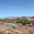
Big Pines Lake is situated in the heart of the Eastern Sierras in California. It is roughly 10 miles west of the small town of Big Pine and around 15 miles south of Bishop. It’s not too far from Mammoth Lakes which makes it possible to experience the best of both worlds while exploring the hidden gems of California.
What is Big Pine Lakes?
Big Pine Lakes is a cluster of seven large plus many other unnumbered smaller glacial lakes in the John Muir Wilderness cradles in the deep mountains of Eastern Sierra Mountains in Inyo County, 10 miles west of Big Pine Town in California. You can access these glorious Alpine lakes, named Frist Lake through Seventh Lake by following The Big Pine Creek North Fork Hiking Trail, which surges into California’s High Sierra towards the southernmost glaciers in the United States.
How to Get to Big Pine Lakes?
The Big Pine Creek North Fork Trail is pretty isolated. It’s located at the end of Glacier Lodge Road, the only way to access this area would be by car. Since it’s rather remote, many might find this location perfect for camping, with parking your vehicles not being too much trouble, as they can remain by the base of the trail. However, if it happens to be full you’ll need to park your vehicle in the overnight car park a little further away. See the map for guidance here.
Best Time of Year to Hike Big Pine Lakes
You might want to visit Big Pine Lakes for an enjoyable and rewarding hike during the late spring – when the snow has just begun to melt off of the mountains – summer or early autumn before the first snowflake tumbles from the pristine skies. Summer is the height of the season, although it can be very hot and much of the trail is exposed to its rays with very little shade.
The weather at Big Pine Lakes is variable, similar to the other locations in the Eastern Nevada mountain range. During the day the temperature can get quite warm, spiking to 93 degrees which is very hot with no shade or breeze. In the spring and autumn, however, the temperatures can dip down quite a bit with the lakes partially freezing by October. Your best bet is to continuously check the weather before taking your trip and prepare for hot, cold, and rainy weather.
Spring to early fall from March to October is the peak season for Big Pine Lakes hiking or camping. For thinner crowds and witnessing the wildflowers bloom, planning a Big Pine Lakes camping trip right after the snow melts during the late spring months is the best time.
There is minimal shade, but the low temperatures make up for it. If you’re hiking or camping Big Pine Lakes during the summer, start early to avoid intense heat while clambering uphill, and consider visiting during the weekdays, if you prefer more seclusion.
Early autumn before the first signs of snowfall, is also a fantastic time to visit Bog Pine Lakes, as the temperatures dip considerably, while the iridescent leaves of autumn, spread beautifully across the landscapes, transforming them into vibrant shades of red, orange, and yellow. Late autumn means the snow is returning, and some of the trails to lakes further down will be blocked.
How Long is the Hike to Big Pine Lakes?
The hike along the North Fork of Big Pine Lakes totals around 15+ miles for those planning to hike to the furthest of lakes. However, most visitors only make it to the first, second, and third lakes, which are pretty much besides each other. Depending on your speed, tolerance to the altitude, and fitness level, hiking to the first lake can take between 3.5 hours to 4.5 hours.
Managing the Changes in Altitude
The starting elevation of the Big Pine Lake trail is around 7,600 feet. The elevation gain, once you reach lake 3, is around 3,400 feet, meaning that it goes up to around 10,500. For the Eastern Sierras, this isn’t the highest altitude you can find, but it is a decent altitude that can prove difficult for others.
Altitude sickness doesn’t affect everyone in the same way. For the majority of visitors, they may begin to notice slight shortness of breath when walking and hiking, for others it’s an issue that can be draining. The further you go, and the higher you climb in elevation, there is less oxygen to breathe, which heavily impacts how your body feels.
The symptoms of altitude sickness can range from mild to severe headaches, nausea, shortness of breath, fatigue, and difficulty sleeping. For most people, symptoms of altitude sickness can begin within a few hours of getting to a higher elevation.
However, there is a delayed reaction that happens to be common amongst those suffering from altitude sickness, as the symptoms spring forth, and disappear making it difficult to grasp the sensations surging through one’s body, blaming them on the slight fatigue that naturally occurs when hiking.
When preparing to go into higher altitudes, the best thing to do is to keep yourself heavily hydrated. Feel the water slosh in your stomach if you have to, knowing that it’s there is better than feeling the gurgling emptiness of its depth. Try drinking electrolyte drinks 24 hours before visiting higher elevations. If possible, continue to drink at least one electrolyte drink per day while trekking through higher altitudes, to help chase the altitude sickness symptoms away.
Additionally, avoid alcohol, drink 3 to 4 liters of water a day, eat more carbs and ascend slowly. If you’re experiencing symptoms that are not eliminated with water, electrolytes, or pain reliever medication, get down to lower elevations.
Hiking Big Pine Lakes
The hike to Big Pine Lakes begins at the Big Pine Creek Trailhead, beside Big Pine Creek Campground and Glacier Lodge. There is also another trail stretching from here to the Baker Summit Trail. The course starts upwards in switchbacks alongside North of Big Pine Creek then morphs into the hillside as the elevation steadily increases.
Many visitors tend to find the first few miles the most challenging because of the steepness as well as the uphill path that would have many staggering to catch their breath, thighs burning with the effort of climbing especially with the sun beaming down on them. This is why you should start this hike in the early hours, with plenty of water sloshing in your belly.
The fatigue and irritation are short-lived, once you meet the splendid views of the valley dotted with Aspen and Pine trees you’ll find yourself suspended in awe at the magnificence of John Muir Wilderness. As you trek through the well-marked trail, you pass by creeks, picturesque cascades, lovely wildflowers, and enough space to take a short pause, and rest beneath the shade.
About 4 miles through the trail, you’ll come across an essential landmark that is the incredible cabin of one of Hollywood’s famous actors – Lon Chaney Sr. The beautiful sophisticated place that is now a Forest Service cabin was once his summer home for a short time. The building is preserved as a historic site, curled within Inyo National Forest.
The turquoise colors of the rippling lakes, caused by the glacial slit trickling down the surrounding peaks, make them look like lost jewels winking in the morning sunlight. Beyond the cabin, you’ll begin to feel the elevation change, as the switchback trail leads out of the forests into the alpine mountains, glimpsing grey granite peaks towering above the valley amidst Aspen and Willow groves.
You’ll eventually reach the First Lake – the first of many lakes – after some time, and you will find your knees trembling at the picturesque views unfolded before your eyes. With a gorgeous cerulean lake, spread against the rugged peaks.
A few moments later, the second lake will appear, it is the largest and most popular due to its bedazzling beauty, and this is where you will find the peaks of the Temple Crag and Mount Alice readily posing for the many enthusiastic visitors snapping dozens of pictures that will soon quickly become visible on someone else’s timeline.
Plodding further along the trail will lead you to the Third Lake, which is nothing compared to the Second Lake. Continue to the fourth lake, and from there you can make a loop to the Black Lake and re-join the trail near First Lake to make your way back.
Hiking to Palisade Glacier Lake
Palisade Glacier is one of the few remaining glaciers in California and the largest glacier in the Sierra Nevada range at 0.81 miles in length. You’ll find yourself enchanted by the breathtaking views of some of the highest peaks of the Sierra Nevada from the glacier.
Hiking Palisade Glacier is another type of adventure worth exploring at Big Pine Lakes trail. If you’re planning to make an ambitious hike to the glacier you might want to camp near one of the upper lakes, as it is almost impossible to do it along with the lakes in a single day.
The hike up to Palisade glacier is steep, mountainous, and involves some off-trail hiking. The path to the glacier is also less used than the main loop, so if you are hanging about earlier in the year, when the snow begins to melt, it is best to bring your snowshoes as it is pretty steep.
With a rapid altitude gaining over 1,000 feet in under 2 miles. The trail passes through a valley littered with boulders and creeks, the last 2.5 miles becoming the trickiest, as the track is not well-marked, rarely trekked, and uphill. You have to make your way forward by climbing up the rocks. Continue along this grueling path for some time, and you will discover the entirety of Palisade Glacier, spotting the first three lakes.
Exploring Big Pine Lakes
Big Pine Lakes Trail in California is one of the most magnificent hikes you can trek in the United States. Whether you are day hiking or backpacking Big Pine Lakes, once you reach the glacial lakes the views will quite literally take your breath away. Just knowing that you are footsteps away from the trembling turquoise lake, is enough to amplify the rhythm of your footsteps, and you push against the slight ache in your thighs, desperate to glimpse its treasured depth.
Along your adventurous hikes, you can take a quick fishing break, jump into the icy waters to shake off the sweat, or camp nearby. Here’s a little insight into what a trip through Big Pine Lakes will look like:
- The trailhead
- Start of the trail
- The lower lakes
- Palisade glacier
- The upper lakes
The Trailhead
Big Pine is a small town of facilities. The road towards the lakes is indicated from US 395 by an unobtrusive sign to the Big Park Lakes Recreation Area and starts by crossing a barren, jagged hillside then climbing steadily alongside the creek, up a shallow valley that eventually becomes decorated with big pine trees, after which the stream was named. The creek is a renowned trout fishing location and has easy access from many places along the highway.
The road stretches past a national forest campsite, an area marked “trailhead parking” for overnight hikers, then ends at a day-use parking area by a junction. On the left is a side road to Glacier Lodge, while straight ahead, past a gate are a few private residences before the road reaches an end. No fee is charged for parking, and no permit is required for the hike unless you plan to stay overnight in the wilderness.
There are two trails starting here: the 5-mile path along the South Fork of Big Pine Creek meets two lakes while climbing 2,300 feet along an open, U-shaped valley, however, the most interesting but longer route – North Fork – passes more varied scenery with stunning views.
Start of the Trail
Hikers first trek along the stream for a short distance, over a footbridge then through a patch of woodland to a junction, which provides a delightful view of the South Fork canyon. Turning right, the path switchbacks up the hillside dividing the two branches of the creek and enters the overgrown lower end of the North Fork canyon, where it crosses the stream a second time and begins to clamber the naked, treeless, north side of the valley.
A track runs a little way along the canyon floor, leading to a campground that is currently closed. After another junction, with a less-traveled path towards the next valley northwards – Baker Creek – the trail meets a rocky area and joins Big Pine Creek just above a 100-foot cascade – Second Falls – a point that marks the boundary of the John Muir Wilderness. For the most part, the remaining path to the lake is quite wooded, the valley floor littered with a mixture of pine and aspen trees.
The next 2 miles of the path run close to the stream but are generally quite high above, all on the north side, ascending steadily with a few short steep sections of switchbacks though other parts are almost level. At one point the trail passes a log cabin built by actor Lon Chaney, set in a shady clearing beneath tall lodgepole vines.
The Lower Lakes
The next junction, 4 miles from the road marks the beginning of a loop past five of the lakes and is best hiked in the clockwise direction since the remainder of the elevation gain (1,000 feet) is done gradually with the route being fairly shady, taking the right branch first involves quite a tiring climb up an open, south-facing hillside.
So, if walking along the left fork, First Lake soon comes into view, like several others the lake is brimming with bright turquoise water, the path runs quite far from the lake though it is easy to scramble down to the water level. A short distance further is Second Lake, the largest and one of many enchanting lakes, with a shoreline of cool granite cliffs and boulders.
Next is Third Lake, a little unrelated to the first two as the water is less colorful and quite shallow. The path then climbs quite high above the west shore of the lake via a short but steep series of switchbacks and leads on through the pine forest to a junction with a spur path to the base of Palisade Glacier.
Palisade Glacier
The path to the glacier isn’t used as much as the main loop, this is mainly due to the fact that it is pretty steep, gaining over 1,000 feet in under 2 miles with the top area not being well defined. From the junction, the trail crosses a valley and a stream then begins ascending a wooded hillside popping through treeline to a small obscured valley called Sam Mack Meadow, which is carpeted by thin blades of grass and large boulders.
A small stream flows freely fed by an unseen lake further up the mountain. The valley is ringed on 3 sides by high distorted cliffs, with a path ascending to the south side, to the top of the ridge then keeps climbing for another mile; veering southeast to the boulder field at the base of the glacier.
Cairns mark the route for a while until the recognizable trail ends, whereupon further uphill progress is made by scrambling across the rocks. Essentially a long walk is required before the glacier becomes fully exposed, at the top of a hillside that seems to stretch forever towards the first, second, and third lakes; this point being 4,000 feet above the trailhead. The mountain slopes higher up are completely void of life, with just rocks and thick snow to show.
The Upper Lakes
On the main trail, the next fork is a four-way junction. Veering left, a short descent reaches the shore of Fifth Lake with a surface elevation of 10,787 feet it is perhaps the most impressive, as it reclines in a large granite bowl, enclosed on three sides by steep rocky slopes and filled with deep, clear cerulean waters.
When continuing straight on at the junction, the path quickly arrives at Forth Lake, embraced by thick pine forest minus the stark granite scenery of the earlier lakes. Past that is the smaller Summit lake and Sixth lake, where the path ends though Seventh Lake isn’t that far off. The final water on the loop path is reached by turning right at the junction and is lined with luscious trees providing brilliant shade to those on foot.
John Muir Wilderness
The John Muir Wilderness stretches for 100 miles along the crest of Sierra. Essentially it is a land of thick snow-capped mountains, deep canyons, and vast expanses of glacially imprinted terrain. Elevations range from 4,000 feet to 14,496 feet with rippling lakes and streams characterizing the wilderness effortlessly.
Pets are permitted to roam the wilderness areas, although you are entirely responsible for their actions and their welfare. It is advised to keep your pets on a leash while exploring the divine beauty of the wilderness and your surroundings, as well as when camping in areas with other visitors. Wilderness visitors who plan to travel to adjacent National Park should be aware that National Parks do not allow pets.
Non-motorized RV opportunities are abundant in the John Muir Wilderness. Explorers of all levels can backpack and set up camp under the twinkling stars and enjoy 589.5 miles of hiking, fishing, climbing, and horseback riding. A wilderness permit is required for all planned overnight trips to the wilderness.
Where to Stay: Big Pine Lakes?
It matters not whether you plan to day hike or backpack the Big Pine Lakes trail, you will need a place to rest for the night that happens to be close by. There are several options for camping right at the trailhead that makes this trip much more enjoyable as it is a bit of a lengthy drive from the nearest town of Bishop, though many people do this from there. If you are planning to stay in Bishop, plan to get up very early as the car park fills up by 7 am in the summer.
Here are a few campsites in Big Pine Lakes that you might wish to consider:
- Big pine creek campground
- Upper sage flat campground
- Sage flat campground
- Glacier lodge
Big Pine Creek Campground
This mini 30-site campground is burrowed along the Big Pine Creek offering a much-needed breather from the scorching hot afternoon sun. The camping ground is small, as are the sites, so if you’re traveling with a group you should consider getting several sites beside each other. The campground is the closest campground to the trailhead, making it the most convenient for day hikers as well as backpackers.
Upper Sage Flat Campground
The next nearest campground for the trailhead is the Upper Sage Flat Campground, especially if you’re in need of a place to stay before you set off for backpacking. The campground is not as shaded as Big Pine Creek but offers many sites and more spaces for groups. This campground is closer to the overnight backpackers’ car park than the main trailhead, so you might consider driving to the trailhead if you’re unsure about the amount of physical energy you will have for the hike.
Sage Flat Campground
Just a little further from Upper Sage Flat is Sage Flat Campground, which is another choice to consider if Big Pine Creek is full. This campground is partially shaded with nice sites along the river, however, the sites aren’t huge, so if you’re traveling with a large group, plan to book 2 sites beside each other.
Glacier Lodge
Glacier Lodge is privately owned but located just outside the gates of the trailhead at the end of the road by the Big Pine Creek Campground. This lodge offers drive-in spots for RVs or tent camping. They also have small rustic cabins available for rent as well as package promotions with pack mules and supplies to head up to the lakes.
Things to Consider Before Setting Up Camp
Before planning to set up your tent, or park your vehicle to camp for the night, you might want to consider these things: for your safety:
- You cannot set up camp closer than 300 feet to the water
- You will be close enough to the water for easy filtration and cooking or cleaning
- You want to look for flat spots that have been used previously which is evident through the lack of rocks and brush
- Many people set up on rocks or cliffs overlooking the water offering phenomenal views in the morning and night. Though it can get windy so make sure your tent is secured so that it doesn’t take off into the skies!
- Remember to store your bear canister at least 100 feet away from your campsites and keep all your scented items in the box at all times.
Swimming in Big Pine Lakes
Amongst the bravest who can manage the icy cold temperatures of the lakes will find it particularly enjoyable to actually dip their toes and bodies in the Big Pine Lakes. Most people tend to dive in and out quickly, which is understandable since the icy depth of the waters can’t be a walk in the park for everyone! The water is very cold and can cause hypothermia so be cautious venturing further into the water even though the heat might tempt you to its addicting pools of coolness.
Fishing in Big Pine Lakes
The seven lakes are great for spin casting or fly fishing, with most activity arising around sunset. Fish tend to rise to the top of the lakes. The fourth lake is quite popularly visited, so is more heavily fished than the others. You can fish for rainbow, brook, and brown trout around the creek inlet on the first lake.
Those with a tad more ambition might prefer to rise in the early hours, hike to the lower lakes in a couple of hours and then spend the entire day fishing from lake to lake, returning to the trailhead before the evening catches up to them.
What Should I Bring for a Day Hike?
Generally speaking, these elements should be with you at all times, whether you plan to hike for several hours, an entire day, or for the week, these essentials will keep you going and they include:
- Water and water filtration to remain excessively hydrated, it’s better to have lots of water in your stomach, than none, lots of water being in your bag can be sipped as you walk along the trails.
- Snacks, food, and things to keep your energy in check
- Hiking poles
- Hiking shoes with good traction
- Moisture-wicking clothes i.e. wool
- Sun protection, no matter the weather always pack sunscreen, sun hat, and any other type of sun protection
Would You Visit Big Pine Lakes?
Enchanting beauty that might have you glued to the spot you’re stood upon, with breathtaking phenomenal views of the turquoise lake pushing against the towering mountains that seem to stretch into the blue skies forever. If you’re planning a quick weekend getaway to Big Pine Lakes, you might want to reconsider and plan to stay for a couple of days longer, as there is no way that you will be able to thoroughly explore the divine beauty that is evident in Big Pine Lakes in 2 days!
Whether you plan to stay overnight in the nearest town, or camp at the sites near the lakes, the choice remains in your hands, how far are you willing to test the adventurous bone in your body?
Other hike-related posts:
FAQs (Frequently Asked Questions)
How long is the big pine lakes hike?
The entirety of the big pine lakes hike will take approximately 7 hours and 47 minutes to complete, an 11 miles roundtrip to the second lake, or 14 miles roundtrip to all seven lakes.
Do you need a permit to hike big pine lakes trail?
You’re not required to purchase a permit to day hike in Big Pine Lakes.
How long does it take to get to big pine lakes?
Depending on your preference, and the obvious enchanting scenery that would require long pauses along the trail, you might need 4 or 5 days to completely explore the entirety of Big Pine Lakes. The steep, 4.8-mile hike from the road end, leads you up the North Fork of Big Pine Creek, past waterfalls, wildflowers, and more.
When should I backpack big pine lakes?
The best time of year to backpack Big Pine Lakes is in very late spring after the snowmelt, summer or early autumn before the first drops of snow cascade from the sky. Summer is the height of the season, though the days are very hot with almost no shade along the trails, you might want to begin in the very early hours of the morning.