Hey! This site is reader-supported and we earn commissions if you purchase products from retailers after clicking on a link from our site.
Joshua Tree National Park is a vast ecosystem full of wonder and adventure for those who seek it. While Joshua Tree is a popular destination for the rock-climbing community, there are hundreds of miles worth of trails for you to discover. Walking these trails bring you up close to the gorgeous flora and fauna that resides in the unique environment of the national park. Whether you are a new hiker or experienced and looking for a challenge, there are plenty of hikes in Joshua Tree to try.
Table of Contents
- About Joshua Tree National Park
- Where is Joshua Tree National Park?
- Fun Facts About The Joshua Tree
- The 17 Best Hikes in Joshua Tree National Park
- 1. Barker Dam Nature Trail
- 2. Cholla Cactus Garden Trail
- 3. Cap Rock Trail
- 4. Lost Horse Mine Trail
- 5. Boy Scout Trail
- 6. Hidden Valley Hike
- 7. Ryan Mountain Trail
- 8. Fortynine Palms Oasis Trail
- 9. Arch Rock Trail
- 10. Black Rock Canyon to Panorama Loop Trail
- 11. Warren Peak Trail
- 12. Split Rock Trail
- 13. Stubbe Springs Loop
- 14. Rattlesnake Canyon Trail
- 15. Crest View Trail
- 16. Mastodon Peak Loop Trail
- 17. Squaw Tank Trail
- Tips to Make Your Joshua Tree Hikes Even Better
- Happy Joshua Tree Hiking!
- FAQs
About Joshua Tree National Park
Joshua Tree is currently 790,636 acres, which is a little bigger than Rhode Island, and has 429,690 acres of purely designated wilderness. Being that the park is between two deserts—the Mojave and Colorado—it has many characteristics of both. You will see the ecosystem of the Mojave at higher elevations, while the lower regions take after the Colorado Desert. On the southwestern edge of the national park, you can see the peaks of the Little San Bernardino Mountains.
The area also has fascinating history that you can witness on many Joshua Tree hikes. For instance, the Pinto people resided in the region between 8000-4000 BCE. In the 1930s, evidence of their life was found in the Pinto Basin. Hunter-gatherers, such as the Serrano, Chemehuevi, and Cahuilla resided around Twentynine Palms, and the Mojave people carved trails through the desert in search of resources.
After the 1870s, when settlers traveled from the east to the west, there were cattle wranglers, miners, farmers, and others around Joshua Tree National Park. Between the 1860s and 1940s, the region of Joshua Tree was pocked with 300 mines. The most successful is known as Lost Horse Mine, which produced $5 million in silver and gold.
Where is Joshua Tree National Park?
Joshua Tree National Park is one of the many in California. The park is to the east of Palm Springs, in the southern reaches of the state, where the Mojave Desert stretches to meet the Colorado Desert. You will also find the cities of Yucca Valley and Twentynine Palms close by, if you are looking for hotels or other places to stay in California.
Fun Facts About The Joshua Tree
Since you are heading to Joshua Tree for some amazing hikes, you might as well learn some trivia, too. These can be amusing if you have children along for the ride or simply want to impress your friends.
- John Fremont, an explorer of the region, described Joshua trees as “the most repulsive tree in the vegetable kingdom.” Most people disagree, as the pom-pom shape of the leaves and branches is rather whimsical.
- Unlike Fremont, Mormon pioneers loved the shape of Joshua Trees (and are accredited with naming them). They saw the limbs of the trees as arms reaching upwards towards the heavens, leading them to a Promised Land.
- A resident of Pasadena, Minerva Hoyt, fought against the removal of Joshua trees and native cacti in the area. In 1936, her effort to protect the plants lead to 825,000 acres being set aside for the formation of Joshua Tree National Monument.
- Nearly 3 million people visited Joshua Tree National Park in 2019.
- The lowest elevation in the park is found at Pinto Wells, where it is only 934 feet above sea level.
- The highest elevation is on Quail Mountain at 5,813 feet.
- While Joshua Tree is between two deserts, there are six mountain ranges covering 1,235 square miles of the park.
- There are 191 miles of trails through Joshua Tree National Park, and many of them have been around for decades.
- Do you love searching for UFOs? Joshua Tree National Park is considered a UFO hotspot, so there are many nighttime excursions pertaining to UFO-watching.
The 17 Best Hikes in Joshua Tree National Park
A sanctuary for hikers who want an easy trek or a strenuous one, Joshua Tree has much to offer. You will find exciting nature hikes for families to enjoy as well as climbs up mountains. If you don’t want to do the hikes alone, you can also join in on guided treks led by the Desert Institute.
Just one thing to keep in mind before you add these hikes to your itinerary: Pets are not allowed on any of the trails in Joshua Tree, except the Oasis of Mara Trail.
Now, check out these 17 best hikes in Joshua Tree National Park:
1. Barker Dam Nature Trail
Consistently called one of the best trails in Joshua Tree, the Barker Dam is where you should begin your hikes. Not only do you see amazing sights, you can learn a little about the history of the park, including the natives who resided here centuries ago. Plus, the Barker Dam is one of the best evidence of the settlers who moved into the region during the 1800s.
These days, the Barker Dam provides the region with a source of water that is beautiful to see. The blue water contrasts with the golds and greens of the desert landscape. Who knows? You may even spot some sheep or other wildlife coming to get a sip of water!
Barker Dam is open for both sunrise and sunset walks—and those are highly recommended. As the sun rises and falls, the stones take on new hues. Want to make your Barker Dam Nature Trail a bit longer? Take the Wall Street Mill Trail once you finish. You see more of the Barker Dam area as well as a gold mine.
Don’t forget about the turnoff that leads to a small cave covered in petroglyphs! It is believed that the petroglyphs describe locations of water.
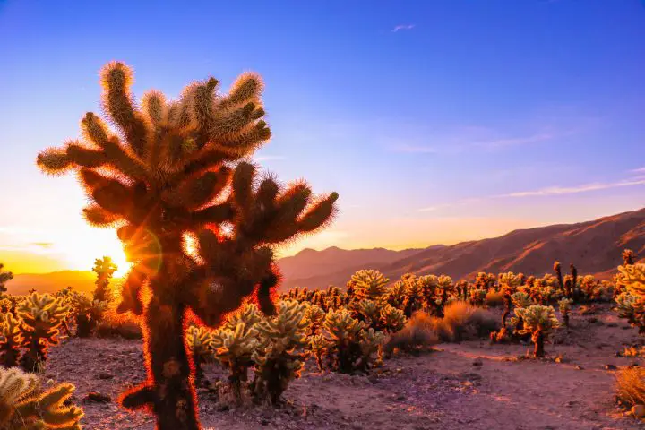
2. Cholla Cactus Garden Trail
Although Joshua Tree National Park was named after the fascinating Joshua trees in the area, you shouldn’t just go for that. If you go to the southernmost point of the park, you find the Cholla Cactus Garden. Here, Joshua trees are replaced with fuzzy, stout cacti that are clustered together for miles. Although the hike is about a quarter of a mile, there are plenty of boardwalks and dirt paths to wander.
Just make sure you don’t get too close to the Chollas, as they are extremely sharp and hurt a lot.
You can visit any time of the day, but you might want to consider seeing the sunrise or sunset here. The golden rays of rising or setting sun transform the area. The fuzzy Chollas become highlighted by the glow; it looks like something out of a fantasy book.
3. Cap Rock Trail
Want to practice some rock scrambling and bouldering? Then you should go to Cap Rock. The Cap Rock Trail is accessible from the Cap Rock parking lot and takes about 30 minutes to complete—if you’re just walking it, that is. If you spend time studying the boulders and clamoring all over them, this trail could take much longer. Kids love this trail for that reason.
You can also take some time to explore the wildflowers around Cap Rock. Be sure to snag a Botanical Trail Guide from a Visitor Center, so you can have an impromptu scavenger hunt while hiking.
4. Lost Horse Mine Trail
The Lost Horse Mine produced 16,000 ounces of silver and 10,000 ounces of gold during its time in operation. Now, it is at the center of one of the coolest hikes in Joshua Tree. The mine ran from 1894 to 1931 and had a ten-stamp mill used for crushing ore and exacting the gold and silver. Parts of the mine and mill remain for you to study, though most of the artifacts are fenced off (to protect it from vandalism).
Follow a preserved wagon trail for about 2.5 miles then onward towards the ten-stamp mill. You might notice that the vegetation diminishes dramatically around the Lost Horse Mine. The loop is about 6.8 miles, but you can turn around at the 4.9 mile mark. At the end of the loop, there are several old mines for you to see from a distance, as well as an old fireplace.
If you want, you can seek out the spur trail behind the mine that takes you towards Lost Horse Mountain. You will see Lost Horse Valley, Pinto Basin, and Pleasant Valley from the peak.
5. Boy Scout Trail
A notable hike for backpacking, the Boy Scout Trail is 16 miles that are not for the faint of heart. If you want to truly invest time in Joshua Tree hiking, this is the trail that must not be missed. Yes, it takes all day (or two) to complete, but you see the park in all its majesty.
The Boy Scout Trail is also more quiet than other trails. You can spot plenty of Bighorn Sheep and tortoises along the hike for that reason. Plus, it takes you towards the Wonderland of Rocks. Begin the hike at the Keys West Trailhead then continue across the desert, past the Wonderland of Rocks, and to Indian Cove. From there you ascend to the upper Mojave desert.
Be sure to reserve energy throughout the hike. The beginning of the hike is in loose sand.
This video details a backpacker’s journey along the Boy Scout Trail; it will give you an idea of what to look forward to:
6. Hidden Valley Hike
Want a quick hike? The Hidden Valley hike is often called one of the best hikes in Joshua Tree because of what you see. The terrain is relatively even and doesn’t require much energy to navigate. That gives you plenty of energy to check out the hidden valley—surprise! There are lovely rock formations and boulder collections, as well the landscape to take in.
Interestingly, this area used to be inaccessible. Then cattle ranchers moved the obstacles out of the way and discovered a valley full of vegetation, including flowering cacti.
Being that this hike is quick and easy, it is great for families with younger children to do. However, if you are running short on time at Joshua Tree, you can swap the Hidden Valley trail for something else, like the Barker Dam. At the end of Hidden Valley is a small picnic area where you can rest your bones, have a snack, and prepare for another, more difficult trek.
7. Ryan Mountain Trail
Fancy a workout? Rated as challenging by many hikers, the Ryan Mountain trail is also another rewarding journey. You go about 5.2 miles roundtrip and end up seeing plenty of gorgeous sights. Be choosy about when you visit Ryan Mountain, as this area tends to be cold and windy throughout the year, especially in the winter. You will also need a windbreaker for the ascent, in most cases.
The hike up the mountain is steep but levels out as you reach the peak. From there, you will see almost all of Joshua Tree National Park. Take a moment to look out in all directions, enjoying the diversity of the park from above. Since Ryan Mountain is a popular hike, the trail is maintained and easy to follow. As long as you take your time, you can finish the loop in about 2 hours.
Ryan Mountain is located between Split Rock, Skull Rock, Hidden Valley, and Barker Dam.
8. Fortynine Palms Oasis Trail
Out and back, the trail is only about 3 miles and has an elevation change of 350 feet. It takes 1 hour and 30 minutes to 2 hours to complete. The main draw to this hike is seclusion and quiet, as well as the panoramic view of the beautiful park. At the end of the hike, you are rewarded with the sight of an oasis swathed in palm trees. It’s a rare sight in a desert but definitely not a mirage!
The trail is well-maintained and has a consistent incline. You will see lines of cacti along the trail, too. The downside? No Joshua trees. That said, this trail is loaded with wildlife. From the desert birds and hawks to the desert-dwelling rodent hiding in the underbrush, it is a beautiful hike to try.
So here is a little history on the palm trees at the oasis: they are not native to the area. Rather, the trees were planted in the 1900s by miners who had found the small pond. They marked the location with the palms. Interestingly, while the fan palms are scorched and scarred from all the wildfires, they are naturally fire-resistant and keep going strong.
9. Arch Rock Trail
Head to White Tank Campground for a short but thrilling hike to Arch Rock. Overall, you go about 0.5 miles from the campground and need about an hour to complete the trail at a relaxed pace. There is only a small amount of available parking, but you can walk from the new lot near Pinto Basin Road, which is north of White Tank.
The trailhead is next to campsite 9. After a slight incline up to Arch Rock, you have to boulder to the top to see the sights. You can also use Arch Rock as an entry point to some trails that lead to a swath of wildflowers in the spring. You can also find a number of points to take photographs.
Want to stargaze? Arch Rock is also popular in the evening. Just remember to be respectful of the resting campers at White Tank.
10. Black Rock Canyon to Panorama Loop Trail
At 6.7 miles total and a moderate difficulty rating, this is one trail that provides you with a decent challenge and opportunities to see Joshua Tree wildlife all around. Despite being a more difficult trail, the Black Rock Canyon to Panorama Loop hike is popular and frequented by visitors throughout the day. The trailhead is at Black Rock Canyon Campground, near High View Nature Loop Trail (a great warm up hike).
For most of the trail, you are moving alongside a stream. Depending on the season, the water may be dried up. Soon, the trail diverges from the stream and starts to rise, leading you to the junction at the start of the Panorama Loop. You can complete the trail in either direction, though it is best to go east, since there is more shade. At the highest elevation, you have amazing views and a chance to relax for a bit before continuing on.
Keep your eyes peeled for all the wondrous plants and wildlife in Black Rock Canyon, such as the fascinating Mojave Mound cactus, which often grows straight from rocks.
11. Warren Peak Trail
Looking for a fun and challenging hike that has excellent views? Warren Peak Trail is similar to Black Rock Canyon to Panorama Loop and starts in the same area. That said, most people consider Black Rock Canyon a warm up for Warren Peak. The trail to Warren Peak is about 5.4 miles long and takes between 2.5-3.5 hours to finish.
You start on the Panorama Loop trail but head west. For a short time, the hike loses elevation, entering a wash that once was a creek bed. Since you are hiking in loose sand, take your time. Also, wear the appropriate footwear. Otherwise, you will be walking around with sand in between your toes!
The wash is, fortunately, not too big. Soon after, the elevation gain is light and takes you to a split in the path leading to either PL (Panorama Loop) or WP (Warren Peak). Follow the arrow to WP.
The views from Warren Peak are worthwhile, and you get to see mountains in the distance on a clear day. Some visible areas include Yucca Valley, Big Bear, and San Jacinto.
12. Split Rock Trail
If you want to hike Joshua Tree in the winter, make Split Rock Trail your go-to. One of the reasons this trail is so popular during the cooler months is the snow. Since it’s at a higher elevation, snow sometimes gathers around the Joshua trees and limns the rock formations. It’s a truly astounding sight to see. In the spring, though, there are clusters of wildflowers peeking out from between the boulders.
Split Rock Trail is also relatively short. It is a 1.9 mile long loop that takes about an hour. The Split Rock loop is also a great place to try your hand at some rock climbing. There are tall rock formations throughout. Nearing the middle, at around 0.8 miles, there is another field of rocks where rock climbers gather. At 1.25 miles in, you may spot an offshoot to a landmark known as Face Rock, which looks like a human face.
Split Rock is also home to bighorn sheep. Stay alert and you might spot one or two grazing peacefully.
13. Stubbe Springs Loop
Do you want to get away from all the crowds and enjoy the fiery desert in all its glory? Then you are going to love the 12.8 miles of the Stubbe Springs Loop. This lollipop loop begins with the California Riding and Hiking Trail then deviates to the Stubbe Springs Trail. There is a variety of terrain to tackle, including charred trees, ridges, flats, washes, and canyons. You will also spot a variety of wildlife and plants, including willows, junipers, and Joshua trees.
Stubbe Spring is an actual spring (though you won’t see the water) that you can find by looking for green vegetation and the skeletons of bighorn sheep. You also reach the Fan Canyon Overlook, giving you a stunning look at Coachella Valley and the canyons.
This trail is rated as difficult for a few reasons. First, navigating the trail can be difficult, as there are sandy washes that hide the actual path. Make sure you bring plenty of water and wear the correct shoes. There is a short elevation gain of 1,128 feet, leading to the overlook.
14. Rattlesnake Canyon Trail
Slot canyons are always a thrilling discovery. Near Twentynine Palms, you will find Rattlesnake Canyon, which is found at the base of another popular scrambling spot, the Wonderland of Rocks. However, if you aren’t much of a rock climber, you are going to love Rattlesnake Canyon. This is where hikers can explore the rock formations at your leisure.
Rattlesnake Canyon is made of granite that has been worn away from repeated rainstorms and flooding. Within the canyon are several tinajas and waterfalls. Plus, the route is not frequented by many people, so you can spend as much time as you want exploring the rocky outcroppings and waterfalls.
After traveling around the canyon, go to Indian Cove Campground. Desert tortoises hang out there between spring and autumn.
The only downside to exploring Rattlesnake Canyon is the, well, rattlesnakes. Come prepared!
15. Crest View Trail
Although the Crest View Trail is only 3 miles in length, you see some of the biggest Joshua trees in the entire park. The Crest View Trail begins in Covington Flats (Covington Crest Trailhead), which is also less trafficked than other regions of the park. This means that you will be alone while studying the pinyon pines, junipers, and Joshua trees. At the trailhead are the remnants of what used to be the largest Joshua tree in the park, which had stood 35 feet high and was 17 feet in diameter.
The rewarding trail brings you towards East Deception Canyon, as well as jaw-dropping views of Mt. San Jacinto. Don’t pass this one up. Also, if you have children in tow, you can be confident with bringing them along for this one. The trail isn’t very demanding and remains rather level.
Just make sure you bring plenty of water and protection from the sun.
16. Mastodon Peak Loop Trail
Do you want to explore the southern part of the national park? The Cottonwood Spring and Mastodon Peak Loop are found amid the Eagle Mountains. At the beginning, you walk downhill towards the palm oasis at Cottonwood Spring. From there, you continue onward to the Mastodon Peak trailhead, which is connected to the Lost Palms Oasis trail.
Immediately, you are guided through a thickly grown area covered in Sonoran Scrub, Bigelow nolina, and graythorn. Then, the trail brings you to a slow rise where boulders and rocky outcrops are seen. In the spring, the Mastodon Peak trail is lined with brittlebush, cholla cactus, and many other stunning plants.
The abundance of color in the desert makes this a popular trail. At the summit, which stands at 3,400 feet, the views are mesmerizing. On a clear day, you can see the Salton Sea, as well as Eagle Mountain.
On the descent, you may happen upon the ruins of Mastodon Mine, which had been operated until 1971. As you reach the final mile of the hike, another set of ruins from Winona Mine are visible.
17. Squaw Tank Trail
Connecting the Geology Road Tour and California Riding and Hiking Trail is the Squaw Tank Trail. It is 4.5 miles in length and stretches the vastness of the desert. Though desolate and dry, this trail also brings you up close and personal to scrub brush, cholla, creosote, and yucca plants. The Joshua trees along the trail are small and stunted from the starkness of the area.
If you didn’t feel like you were in a desert on any of the other trails, this one will remind you how arid a place can be. The trail doesn’t have much of an elevation gain, but there is plenty of loose sand to slog through. You have plenty of time to take in the view of Ryan Mountain from afar, as well as the Hexie Mountains. Reptiles and jackrabbits also frequent the area (more than people, for sure).
This hike is best done during the early morning hours, since it is exposed and gets hot quickly.
Tips to Make Your Joshua Tree Hikes Even Better
Now that you have learned about the best hikes in Joshua Tree, here are some tips for making the most of the journey:
- Joshua Tree is accessible. Anyone in your group that is in wheelchair or has a walker will be about to enter for free with a Interagency Access Pass. You can obtain it at the entrance of the park and use it for any national park in the US. Furthermore, the three visitor centers are accessible, and the Lower Keys View Overlook, Oasis of Mara Trail, and Jumbo Rock and Black Rock Campgrounds are paved.
- There are no concessions. You will have to bring your own water and food for your hiking trip to Joshua Tree.
- Do not trust tours from Palm Springs that promise to visit Joshua Tree, as many of them only take you to the edge of the park.
- Come prepared for heat! Joshua Tree reaches averages of 100 degrees F (38 degrees C) in the summertime. If you want a cooler time to visit, choose autumn or spring, when the temperatures range between 50 to 83 degrees F (10-29 degrees C).
- Elevation changes also bring temperature changes. Some areas experience a 10 degree drop or more (minus 12 degrees C or more).
- Before heading to the overlooks or to Keys View, ask the park rangers about the haze conditions. Sometimes the haze is so thick, you can’t see anything.
- Between February and April, there is an explosion of wildflowers. This is dependent on temperature and rainfall.
- Pick up a species guide at a Visitors Center so you can identify all the amazing birds and animals in the park.
- Be careful about where you step! Many of the plants and micro-organisms in Joshua Tree are very fragile and can be permanently damaged.
Also, check out this informative video on Joshua Tree Hiking Tips:
Happy Joshua Tree Hiking!
Now that you know about 17 of the best hikes in Joshua Tree, you’re probably itching to strap on those hiking boots, right? Which trail do you think you will try first? There are definitely many exciting experiences to be had at Joshua Tree National Park, so be sure to go prepared. Remember to Leave No Trace while hiking, and pay your respects to the marvelous Joshua trees that lead the way!
FAQs
What is the hardest hike in Joshua Tree?
There are a couple strenuous hikes in Joshua Tree, but the ones that have been ranked among the hardest are Warren Peak Trail and Ryan Peak Trail. Both hikes have steep inclines and require the appropriate gear to complete. Warren Peak trail takes about 3-4 hours to complete and will have your leg muscles weak by the time you finish. Other difficult hikes in Joshua Tree include Mastodon Peak, Wall Street Mill Hike, Boy Scout Trail, and Squaw Tank Trail Hike.